The Georgia section of the Atlantic Intracoastal Waterway has a terrible reputation among regular boaters that make the annual trek from the north to their winter cruising destinations or returning from their southern destinations to points north. In some respects, that reputation is deserved, but it may also be a bit exaggerated. The ICW in Georgia has been neglected for a very long time. There have been no funds for dredging for many years and there is no immediate relief in sight. But funding is not the only issue. If the Corps of Engineers were to get all of the money they need for dredging, they still couldn't get the job done. The biggest roadblock is the logistics of removing and disposing of the dredged material. There are no locations on the water where the materials can be relocated, and removing the materials and putting them elsewhere is a logistical and financial nightmare. But the news isn't all bad.

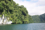
In fact, the Georgia ICW is one of our our favorite sections of the waterway. In our opinion, the sheer beauty of the winding rivers, creeks and bays, and the many anchorages in the marsh grasses, make for a wonderful trip over the 90+ miles. There are very few stretches of the ICW where so many anchorages can be found just around the next bend. A days run can be as short as an hour or two or as long as you like. When you're tired, there will be a place to drop the hook and relax for the evening. Very little of the waterway is as developed as one finds in Florida or the Carolinas. It's this remoteness that we like the best. But navigating these waters does offer some challenges. But the challeges are not any more insurmountable than many places in Florida, South Carolina or Virginia.
Despite the Georgia ICW's reputation for shoaling, the problem areas are only in a few spots. Of course, deep-draft boats will have more of an issue than shallow drafts like
Beach House. On our sailboat
Sea Trek with a 6-foot draft, we were constantly concerned with water depths. The 4-foot draft of
Beach House makes even the shallow spots at low tide nothing more than a nuisance. We have transited many of the reported very shallow stretches at dead low tide and not found the shallow depths that others have reported. There may be a couple of reasons for this. Number one may be that it is sometimes difficult in the winding channels to tell if the boat has gotten out of the channel on one side or another, and strong currents can quickly push the boat into skinny water. Another problem occurs when running the boat close to the channel markers instead of staying in the center of the channel. In many cases, the markers are sitting in a foot or two of water and the center channel will have plenty of depths. That isn't to say that water depths don't vary from one side of the channel or the other. Some good sources to find the most current information on problem spots along the Georgia ICW are our own
Navigation Notices at Marinalife, and our good friend
Claiborne Young's website, Cruiser's Net.
Keep in mind that the tides along the Georgia ICW can average 7 to 8 feet. This means that even the shallowest spots can easily be transited by almost any boat at high tide. It has been our experience that the high tides most often occur at times that make transiting at high tide not very practical. But with the right timing or the patience to wait, there is no reason that a boat with even up to 7 or 8 feet can't do the transit and enjoy it as much as we do. Let's consider a few of those problem areas and how the trip can easily be done. One major problem is not so much shoaling, but too many Skippers blindly following their chartplotter. Cumberland Dividings, which is just north of the Kings Bay Submarine Base, is deep and well-marked. But the chartplotters will show the magenta line along the ICW and if followed closely, will put the boat hard aground. If the channel markers are followed, the boat will always be in deep water and there will be no problems.

There are several narrow cuts along the Georgia ICW and one that has been a problem for boaters is appropriately named Hells Gate. To navigate these cuts, try not to turn directly into the cut from the river. Instead, stand well off the cut and turn toward it, adjusting for the set of the strong currents. This will allow for adjusting the steerage to account for the current and not get swept into shallow waters by the current. Take these cuts down the center and look behind the boat to see the effects of the currents. Our transit at low tide found the least depths to be 6 1/2 feet. Another problem area is the Little Mud River. This stretch is notorious for shoaling, but the reality is that there are only a few spots with very shallow water. One of those spots is only about 4.9 feet at low tide. If you draft is deeper than this, then a transit at mid to high tide will be required. If northbound, anchorages can be found along Buttermilk Sound or the South Altamaha River to wait for the higher tides. If southbound, there are many options on the Rockdedundy, Darien, South or North Rivers. For deeper-draft vessels, waiting for the right tide is a good tactic and will result in a stress free passage. Crossing the Savannah River is always fun for us. Maximum ebb or flood can produce currents of 3 to 4 knots and we often find the boat pointing either up or down river as we "crab" sideways to reach the ICW channel on the opposite shore. Fields Cut, just on the north side of the river, is another shallow spot with depths at low tide of just over 6 feet. The deeper water can be found on the east side near pilings from an old dock that is now gone and only the pilings remain. The rest of Fields Cut has plenty of water with the exception of the very northern portion where depth again drop to 6 feet briefly.

There are several Sounds to transit that can be uncomfortable and challenging if the conditions are not right. Jekyll, St. Simons, Altamaha, Doboy, Sopelo and St. Catherines Sounds all bring the boat out near the open waters of the Atlantic. Even a moderate breeze that opposes the incoming or outgoing tides can result in some nasty seas and a very uncomfortable ride when the boat needs to be turned beam to the seas. The good news is that these transits are short and if the seas and swells are uncomfortable, it will only be for a short period of time. But it is necessary to make sure all items inside the boat are secured and can't be tossed around in the rough waters. If possible, try and transit the Sounds either during slack water or while the wind and current are coming from the same direction. Despite the challenges, the Georgia Intracoastal Waterway is still some of our favorite stretches of the ICW. It's all part of the adventure and once you have done it, you realize just how beautiful it is and how exaggerated the problems really are. Now on to the Carolinas.


Good advice, Chuck and Susan. My trawler drafts 5' and I had no problems the entire Georgia ICW, except when I misread the channel markers just north of the Kings Bay Submarine Base. The red/green changes sides here, and I picked one set too early. :)
ReplyDeleteThe trip from Isle of Hope (Savannah) down to Brunswick was easy, with one overnight anchorage at Sapelo Island. South from Brunswick, plan on anchoring at Cumberland Island for at least a day or two to walk the island and beaches and to see the feral horses.
As you suggested, I avoided crossing the sounds open to the ocean when the wind was anywhere out of the east. We were living aboard at the time and we had too many things that would fly off shelves. Plan on taking your time, don't travel on a schedule, and everything is fine.
All good info and advise. Thanks.
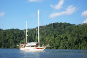
DeleteOur homeport is Jekyll Harbor Marina. The old boat you picture in this post is the O.A. Bloxom just in front of the marina on the icw. The current owner is a Boat US Captain. The capt. says almost all his tows for grounding are operator error. We have an old trawler we are restoring slowly. We take week long cruises up and down the ICW with our 4 ft draft and so far no problems. We watch the tides, ask for local knowledge and check the charts. We cruised to Savannah a week ago with no problems, anchored out at Blackbeard Island for a few days and had a wonderful time. We enjoy your book and blog. Thanks for all you share.
ReplyDeleteWe couldn't agree more that many so called problem areas are due to reports that are derived from operator error. Having said that, some areas do need to be transited with caution and playing the tides. We often pass over these "problem spots" and find no problem, just as you have. Thanks for the info on the vintage boat. Good luck on the restoration, we feel your pain and joy. Chuck and Susan
DeleteI do hope when you transit the ICW near Jekyll you stop by for a visit. I will also ask you to review the anchorage at Blackbeard Island as we feel it is a very special place on the ICW to anchor for a few days or? We have dropped the hook there many times on our travels in our sailboat and now our trawler. Thanks for all
ReplyDeleteSonny and Jean
Thanks for the invite. We will be heading south on the Chesapeake in about a week and will begin working our way south. We'll be posting here when we get closer and would look forward to meeting. Chuck and Susan
Delete