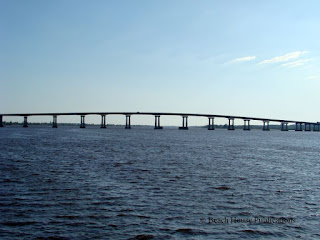
The weather turned out to be another non-event. It sure would be nice if the National Weather Service could get it right, good or bad. Usually we wouldn't head out in winds forecast to be 20 knots, but since the forecasts have not even been close lately, and the conditions were light in the morning, we planned to leave, so off the docks we went. North of Georgetown, SC is the Waccamaw River. Every time we transit the Waccamaw, we remark how it has an almost primeval feel to it. You can imagine that it looked the same hundreds of years ago when the first explorers poked into the many tributaries and creeks that branch off the main river. This has to be one of our favorite stretches of the waterway. Just past Georgetown at the northern end of Winyah Bay, the 65-foot bridge that crosses the southern end of the Wacammaw begins the most spectacular section of the Atlantic Intracoastal Waterway. The waters of the Waccamaw are a dark coffee color due to the tannins leached from vegetation. To us, this adds to the beauty of the area.

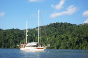
The river is wide and deep, and depending on wind direction, there are many places where a boat can pull off to the side and anchor for the evening, or a day or two. In addition, there are many smaller creeks, rivers and "oxbows" that are deep enough for almost any craft to drop the hook and spend as much time as you would like. Our preferred anchorage after Georgetown is behind a small island near Enterprise Landing, but this evening we planned to anchor either in Enterprise Creek or the turn that continues the Waccamaw leading to Conway
(page 21, The Great Book of Anchorages, Norfolk to Key West). In the end, we chose the anchorage off the ICW in the river. There can be some small boat traffic here, but after the sun goes down, it gets quiet and peaceful. We shared the anchorage with a pair of osprey who had a nest full of young ones. You may also see bald eagles and even bears along the river.

Anchoring along the river can offer some challenges. The banks are lined with beautiful cypress and oak trees. Visible along the banks are many very large tree stumps, both above and below the water surface. It's not unusual to see entire massive trees floating down stream in the currents all the way to lower Winyah Bay. It is possible to get your anchor snared by one of these stumps or trees, making retrieval impossible without a trip over the side and into the water. Many advocate the use of a trip line and float that allows the anchor to be pulled up backward and hopefully pulled loose from whatever has it entrapped. This will usually work, but there is a downside to using these lines and floats. Quite often the winds and currents will be opposed, and the boat will find itself sitting directly over the anchor. If a line and float are attached, they can become fouled in the propeller, rudder, keel or stabilizer fins if the boat is outfitted with them. This can be a serious problem if the entangled line pulls the anchor loose. Now you have no anchor and the whole mess has to be corrected quickly before the boat drifts into shallows and the entanglement gets worse. You get the picture. We avoid using a trip line by NOT anchoring close to the banks, anchoring in areas we know well and avoiding the small, shallow oxbows. Even then there are no guarantees. We haven't had this problem...so far.

We hate to have a schedule since it makes us do things that we might not want to. But we did have friends to meet in Myrtle Beach, so we passed on the opportunity to visit Conway and left the anchorage the next morning. A fuel stop at Osprey Marina delayed us for a couple of hours. The marina doesn't open until 8:00 AM and when we arrived, there was an 80-foot power boat at the fuel dock filling up. Osprey usually has the best fuel prices in the area and we were getting low. The next fuel docks farther north were considerably more, and filling up with 200 or more gallons can be expensive. We use both
Marinalife and
Cruisers Net fuel price pages to find the best deals on diesel. The information from both sites seem to be the most up-to-date. After fueling, we began the trek to Myrtle Beach. One thing we try to do, but often don't, is to stay put on weekends, especially when traveling through tourist areas. This was a Saturday and the tourists were out on the water en masse. The hoards of jet skis and rental boats almost drove us nuts, but we made the marina where we planned to meet our friends by just after 1:00 PM. We tied up at the Myrtle Beach Yacht Club for a couple of days while we visited
MV "Diamond Girl" and also celebrated our own anniversary. The visit went very well and the marina even became a new vendor for our
anchorage books.

The visit went well and we had a delicious anniversary dinner at the Officer's Club. Boating is a weather driven lifestyle. The day we departed from the marina was forecast to be a little breezy with a slight chance of rain, but the wind and rain would pick up overnight and into the next day. Our plan was to make some distance and try to get up the Cape Fear River before the winds increased and while we would have a favorable current with wind and current from the same direction. Two inlets north of Myrtle Beach that are always problem spots are Shallotte Inlet and Lockwoods Folly. Shallow water and strong currents make these inlets challenging to say the least. At Shallotte Inlet, we found one area that was 8.5 feet deep. In Lockwoods Folly, the lowest depth we saw was 6.5 feet deep. Both inlets were transited near low tide. It is very important to stay in the marked channel, especially in the areas where floating buoys are constantly being moved to show the shifting channel, so we don't blindly follow the chartplotter. It's easy to get swept out of the channel in the strong currents at the inlets. Keep an eye out fore and aft to make sure you are still the channel.

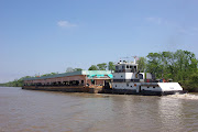
The Cape Fear can be a very slow and very, very uncomfortable ride in the wrong conditions. We have made some sloppy transits in the past and wrote about it in a
previous post. Other than a couple of rude and inconsiderate boaters that even the commercial barges were complaining about, this may have been one of our easiest passages on the Cape Fear. We had a quick ride in the northbound incoming tide, and the southwest winds on the stern made the afternoon comfortable and kept the seas flat. There is always a lot of activity on the Cape Fear--tugs and tows, ferries, large ships and pleasure craft--coming and going continuously. A sharp lookout is needed at all times. We generally run just outside the ship channel buoys to stay away from the larger vessels while staying in deep water. Going up river, we stay just outside of the red buoys. Turning off the Cape Fear and heading up the channel to Snows Cut requires paying close attention to the cross current and not getting swept out of the channel. The depths out of the channel are very shallow, and the range markers that helped keep boaters in the channel are long gone. You will have to spend as much time looking behind the boat as looking forward to judge the boats position in the well-marked channel. The cross current is the strongest at the entrance to Snows Cut. Once in the cut, the going will either be very fast or very slow depending on whether the tides are incoming or outgoing from Carolina Beach Inlet.

Shortly after passing under the 65-foot bridge that crosses Snows Cut, the entrance to Carolina Beach is to starboard. The city of Carolina Beach has installed moorings in the area where we usually anchor. The moorings are $20.00 per night and since we only planned to anchor overnight and leave very early, we didn't see the sense in paying for a mooring. Once inside the harbor, we found there was still plenty of room to anchor. To port, there is a small island covered with saw grass. North of the small island the charts show 30 feet of water, but about halfway in, the depths are actually about 10 to 12 feet. It does shoal up quicky close to shore on the eastern side. We found a spot in about 11 feet and dropped the anchor near the small island. The holding is very good here. The island gave us perfect protection from the building southwest winds. Carolina Beach is a busy beach resort town with all of the attractions and boating activity that come along with that. There is a public dinghy dock for boats using the moorings or at anchor, but it's a long ride to the head of the harbor from the anchorage or moorings. We have heard that the city plans to build another dinghy dock near the moorings. This location would be very near the beach. The winds did pick up overnight, but the rains passed to the north and south of us, so we were spared. The next morning we would head out for Mile Hammock Bay, about 65 miles up the ICW.


No comments:
Post a Comment
Note: Only a member of this blog may post a comment.