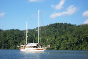
 We have done the ICW so many times that we pretty much know from day to day where we want to be and where we plan to anchor or at which marina we want to stop for the night. But we still also like to try and find new spots, especially since we are no longer burdened with a six foot draft to limit access. After we have anchored or docked for the evening, had showers and dinner and are ready to relax, we still take the time to get out the charts and and plan the next days run and where we want to wind up. Included in our plans are fall back points in case of problems, weather or whatever and also fall forward points in case things go better than planned. We always say our plans are written in the sand at low tide.

 We spent a very relaxing day at our anchorage in Jonaquin Creek with great protection and good holding. We spent the day watching TV compliments of DirectTV and our Follow-Me, now Track-It, system, which did a great job of holding the signal as we danced back and forth in the 25+ MPH winds that came through the anchorage. We did some reading and just rested up in preparation for our next push. The forecast 15 to 25 MPH winds would make the trip up the Neuse River a real efforts so the 24 hour delay was worth it and saved us the stress. By the time we pulled up the anchor and headed out on the Neuse, the winds, although right on the nose, were only about 10 MPH. It was still a little bumpy, but by no means rough.
The trip down the Neuse to the Bay River is about 20 miles and eventually the wind switched around to our stern quarter making it more comfortable. But as we came out of our protected anchorage the light winds were decidedly cooler than anything we have had to date. We immediately moved from the flybridge to the inside steering station. Have I mentioned how much we really, really like having an inside steering station?


The trip up the Neuse and Bay Rivers went quickly and once we turned into Gale Creek and the cut that runs through and past Hobucken, the winds were blocked and the waters calm. The other side of the cut brings you out on to Goose Creek and then the crossing of the Pamlico. This can be another rough patch if conditions are not right. We had the wind and waves on our beam across the Pamlico and up the Pungo River but it was not uncomfortable and as the day progressed the winds were lower. The 18 miles up the Pungo, past Belhaven and toward our anchorage had the currents with us and helped us make better time than we expected. Our planned anchorage was a small creek just before entering the Alligator-Pungo Canal, where we had anchored in the past.
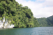
But because we were seriously behind for this entire trip and we were ahead of our schedule for the day, we decided on our fall forward plan. Using both the chart plotter and the computer, we determined that we could easily make the next available anchorage with good daylight to spare, so we pressed on. The Alligator-Pungo Canal is absolutely beautiful and you have the feeling of complete isolation. Care needs to be taken through here since there are numerous tree stumps along both sides and a few almost reach the center of the channel. They are easily seen but you need to be aware.

Exactly as our plotters predicted, we reached our anchorage for the evening just off the waterway off Tuckahoe Point at 5:45 PM. At 81 miles, this is our all time best run for a single day on any of our previous trips. Another big plus for the trawler. This is the lower section of the ICW on the Alligator River and one of those spots where we have not anchored before. One of the things we did not count on were the military jets doing exercises over us just after the sun went down. There was one small sailboat anchored some distance away from us and a couple of large power boats anchored a mile or so up the river. We had seen more boats heading south on this leg than all of the other days combined. Most were sailboats but there were also several trawlers. The winds had pretty much dropped off after sunset and it looked like a peaceful evening once the jets went home.


 Up with the sun and under way at 7:00AM the next morning with sunny skies, cool temps and light winds for the trip up the Alligator River. We arrived at the bridge at 9:30AM and with only a few minutes delay, we were heading out onto the Albermarle, another body of water that is very unforgiving in bad weather. But this morning it was kind to us and with light winds and a chop of less than one foot, we crossed quickly and comfortably. Once across, you enter the North River for about seven miles. We have anchored in both the Alligator and North Rivers often by just turning out of the channel and heading for shore until we ran out of depth.
Which side would depend on what direction the wind was coming from. After the North River we passed through Coinjock and a spot where we have often stopped at one of the marinas. This time we again pressed on, mostly because the marinas have raised there rates to the point that you would think they were in South Florida instead of on a canal in North Carolina. After Coinjock we came out onto
Currituck Sound and the North Landing River. This is a very wide and shallow expanse of the waterway. The channel is twelve to sixteen feet deep, but outside the channel it is only a foot or two in most places. The area has a reputation for side currents in certain wind conditions and even with the ten knots of wind we had, it was choppy. As we progressed north the wind, which was forecast to subside, picked up. Just as we came out of the wide expanse of the river and it narrows considerably, is a small creek called Blackwater.
The guides warn that the entrance is only five feet with seven to ten feet inside. We never saw less than seven and a half feet at the entrance. The bottom is soft mud and it took two tries to set the anchor. We can attest that the creek is seven feet almost right up to the marsh reeds about a quarter mile in. Occasionally you can encounter small boat and jet ski traffic and probably more so on the weekends. This was another of those good days and we had covered a bit more than 75 miles on this leg. We have covered more ground in three days than we had previously covered in a week. Our destination for the next day is Great Bridge, Virginia, only 18 miles away. We will still get an early start to get us there early. Our anchorage in Blackwater Creek puts us in Virginia.


 This turned out to be a great anchorage although we would recommend it for fair weather. At 7:10AM we were under way and headed for the first bridge at North Landing. We made the 8:30AM opening but it was iffy for a moment. They were working on the bridge and the first attempt to open it did not quite work. It closed, then reopened and all was well. The ICW had a light fog initially, but then it became sunny and clear. The water on the Albermarle and Chesapeake Canal was smooth as glass and we took some great photos. Our second bridge was Centerville, five miles away, so we slowed down and took our time for the opening on the hour. We did not want to try and make the five miles in less than thirty minutes. The bridge tender at North landing was as nice as could be and the bridge tender at Centerville was as grumpy as can be.
What a difference just a few miles can make. By 10:00AM we were tied to the fuel dock at Atlantic Yacht Basin in Great Bridge to top off the fuel tanks. We probably could have made it all the way up the Bay but at $2.18 a gallon for diesel, we decided to not pass it up. The marina allowed us to top off our water tanks and sit at the dock for another 45 minutes until the bridge opened at 11:00AM. We also heard our friends on Diamond Girl calling someone on the radio so we called them. It seemed they were just north of us and we both had plans to tie up at the free seawall between the bridge and the lock for the evening. Another coincidence was a phone call from friends from Beaufort who just happened to be in Great Bridge and were wondering where we were. It is truly a very small world sometimes. It looks like this stop will be a bit of a social event for us and we have plans for dinner to get our much needed pizza fix at one of the local restaurants tonight.


No comments:
Post a Comment
Note: Only a member of this blog may post a comment.