
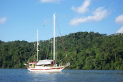
The Okeechobee Waterway is considered by many to be the dividing line between Central Florida and South Florida. When traveling from the north, this is where you will begin to see greater changes in the climate and vegetation, and even in the people—more “Northerners,” either seasonal “snowbirds” or full-time transplants, and a decided increase in the Latino culture. And please journey along with us on our photo tour of the Waterway here.
During the last week of May 2011, we transited the Okeechobee Waterway from Stuart, Florida to Ft. Myers Beach Florida. You can read about our transit here and here and get even more details.
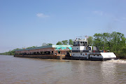
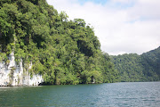
Opened in 1937, the Waterway offers a chance to see rural Florida, with small towns much as they were early in the last century. The scenery varies as the passage progresses from east to west from river to canal, to lake, to canal, and back to river again. On the Okeechobee Waterway, ranches and big commercial farms alternate with moss-hung wilderness, while bustling boomtowns coexist alongside sleepy villages that popped up long before Miami was built. With its backwaters and “bywaters,” its islands and coves, and its flora and fauna, the Caloosahatchee River was once the only way to get from the Gulf of Mexico to Central Florida, via small steamers and freighters. Some still consider the Caloosahatchee (76.6 miles) the most scenic part of the Okeechobee Waterway, thanks to the old river’s off-channel oxbows. Small cruise ships now occasionally make the trip.

For the boater, the Okeechobee Waterway and Lake Okeechobee provide quite a transition from the pace of busy coastal cities to the tranquility of Florida’s heartland. The Waterway is also a tremendously efficient route from the east coast to the west coast of Florida, the only alternative being the long trek down around the Keys and up across Florida Bay, or vice versa. The Okeechobee Waterway is 154 or 165 statute miles (134 or 144 nautical miles), from the Atlantic Ocean to the Gulf of Mexico, depending on whether you take Route 1 across Lake Okeechobee (8.6-foot depths in 2010) or the Rim Route (6.0-foot depths also in 2010; use at your own risk because of debris) along the lake’s southern shore. The Waterway can be divided into three distinct sections:
1. From Mile Zero (the intersection of the Okeechobee Waterway and the Atlantic ICW at St. Lucie Inlet) up the South Fork of the St. Lucie River to the St. Lucie Canal to Lake Okeechobee.
2. Lake Okeechobee itself (either the “Open-Water Route” directly across the lake, or the “Rim Route” along the lake’s southern shore).
3. From Clewiston through the Caloosahatchee Canal and down the Caloosahatchee River to the end of the Okeechobee Waterway in San Carlos Bay, at Mile Zero of the Gulf Intracoastal Waterway (GIWW) heading north.
On Lake Okeechobee, a skipper has the choice of two routes for crossing. The first, Route 1, is an open-water crossing (39 statute, 34 nautical miles, 8.6-foot controlling depths at publication), and the second, Route 2 which is also referred to as the Rim Route (50 statute, 44 nautical miles, 6.0-foot depths at publication; use at your own risk), follows the shoreline south from Port Mayaca, on the eastern shore, before entering a tree-protected rim canal and running past Clewiston to Moore Haven.
Cruising Characteristics
Chart 11428 covers the area from the intersection with the Atlantic ICW to Fort Myers, and Chart 11427 continues down the Caloosahatchee River to the Gulf Intracoastal Waterway (GIWW) and the Gulf of Mexico. From that point, cruisers have the option of moving north on the GIWW to the Sun Coast, outside in the Gulf to the Big Bend or the Panhandle, or south to southwest Florida and the Keys.
Caution: Much of Chart 11428 is at a scale of 1:80,000; this is different from the charts adjoining at either end, 11472 and 11427, both at 1:40,000, the usual Waterway scale. Chart 11428 has two insets at its eastern end and one where it reaches Lake Okeechobee, plus an extension at its western end—all of these are at various larger scales.

Navigating Locks
The water level in Lake Okeechobee is higher than anywhere on the Atlantic Ocean or Gulf ICW. Whether you are headed east or west, you ascend through the locks to Lake Okeechobee, and then descend after you leave. The Waterway has five modern, spacious and well-handled locks and more than 20 bridges, ranging from electronic-controlled to hand-operated. Normally, locks operate between 6 a.m. and 9:30 p.m., but check ahead for current lock-through schedules.
Locking through is simple compared to procedures necessary in the northeastern U.S. canal systems. Lock personnel furnish all necessary lines and regular fenders will suffice when locking through. Allow approximately 15 minutes once inside a lock. The Okeechobee Waterway locks are easier to transit when you are the only boat locking through, and if the lock attendant gives you the windward dock line first when winds are strong. Gusty winds can set up a surge in the locks, so use caution. The attendant also might warn you that you could be locking through with a manatee or an alligator. Lockmasters on the Okeechobee are usually helpful and courteous.
Note: The U.S. Army Corps of Engineers requires boat operators to turn off radar units during lockage to avoid exposing lock personnel to possible radiation risks. It is recommended, however, that engines be left running.
When you reach the dolphins and the sign ARRIVAL POINT before each lock, contact the lockmaster on VHF Channel 13, give your vessel’s name and direction, and request lockage. At that time, they will inform you of the current lockage status and estimate your wait time. It could be as long as 45 minutes to an hour in the unusual case where they have just started locking through from your side. The lockmaster will also instruct you as to port- or starboard-to, indicating which side of the lock to steer to and how to arrange your fenders; see the Bridge Tables in the Skipper’s Handbook section for the side normally used. The lockmaster will then indicate for you to enter when the traffic light is green.
If you receive no response on VHF, sound two long and two short blasts. (Not a part of the Waterway, Clewiston Lock is used to leave the Waterway and reach the facilities at Clewiston; it is the only lock without VHF radio.) At each lock, for the smallest of craft, there is a pull-cord hanging down by a sign marking its location. The green light is your signal to enter the lock. The lockmaster will then hand you, or drop to you, a bow line and a stern line, or the lines will be hanging down from the top of the lock’s sidewall and you will have to steer to them and pick them up (in this case, keep a boathook handy).
When your boat enters at the lower level and is to be raised in the lock, take care that the line does not hit you in the face when it is dropped by the lockmaster. Be prepared for moderate turbulence as water rushes in or out of the lock. Two people can safely handle a small or medium-sized boat, but an extra pair of hands is always useful on large boats. Single-handing through the locks is not safe and is strongly discouraged.
Check when you are doing your pre-cruise planning, and recheck again at the first lock, to make sure the entire Waterway is open. Maintenance on the locks is normally done each summer, and through-passage from the East Coast to the Gulf Coast may not be possible for as long as several months. During such times, Lake Okeechobee may be accessible from one side or the other, but not both. During a drought, lockage may be restricted depending on water supply. Call the Corps of Engineers at Clewiston (863-983-8101) for information or go to the Internet at www.saj.usace.army.mil and use the “Coastal Navigation” selection from the menu, followed by the link to “Navigation Projects and Studies.”

Depths and Clearances
The depth of water in Lake Okeechobee can vary widely as a result of rainfall onto the drainage area to the north and the lake itself. As a result of an ongoing drought, the level fell to a record low of 3.36 feet in mid-2007 — the lowest level ever recorded — but lake levels had recovered to 8.6 feet in early 2010, due to hurricanes in 2008 and a tropical storm in 2009. The Corps of Engineers and the South Florida Water Management District manage the level of the lake. There are a variety of ecological, environmental and economic reasons for various levels, and some of them conflict with others.
The depths charted in Lake Okeechobee are based on a datum of 12.56 feet. If skippers know the lake level, they can determine the difference between the datum and the current level and modify the charted depths accordingly. Depths in the sections between dams on either side of the lake vary slightly with lake level changes, but the differences are seldom enough to affect navigation.
The Port Mayaca Railroad Bridge, Mile 38.0, sets the 49-foot controlling vertical clearance of the Waterway. If you have any questions about clearance, call the Corps of Engineers at Clewiston (863-983-8101). Sailboaters can have their masts unstepped at Stuart, or wait and have it done at the Indiantown Marina, which is closer to the Port Mayaca Bridge.

Navigating the Okeechobee Waterway
With the exception of a lake crossing in imperfect weather, passage along the Okeechobee Waterway is easy, piloting is simple and navigational aids are adequate for daytime running. Aids to navigation are numbered in several sequences from east to west all the way across; even-numbered red aids are on the starboard side (as they are southbound along the Atlantic ICW). Conversely, leave red aids to port eastbound on the Waterway, as you would when northbound on the ICW. Reservations are recommended at marinas on the Okeechobee Waterway.
Nighttime navigation is not recommended, because shoals and deadheads (partially submerged objects) are obscured. Fortunately, ample facilities and occasional anchorages make after-dark travel unnecessary. Some of the bridges operate daily from 6 a.m. to 10 p.m. and require a minimum of three hours notice to open at other times. Phone numbers are posted on each bridge; calls are best made during normal office hours. You can use adjacent dolphins for tie-ups. Anchoring in approach areas to some of the locks is also possible, and the lockmasters can provide local knowledge concerning depths and conditions. As mentioned before, aids to navigation are the same as the ICW pattern: going west, keep red aids to navigation to starboard, green ones to port; yellow squares and triangles are shown on dayboards and buoys.
Currents are not a problem in the Okeechobee Waterway, except for the turbulence that occurs when locks are opened. Average tides at the mouth of the St. Lucie River are 0.9 feet; 1.2 feet at Fort Myers; and 2.4 feet at Punta Rassa (at the western end of the Okeechobee Waterway) near Mile Zero of the GIWW heading north.
Weather
Central Florida weather is generally benign. In winter, the prevailing wind is north to northeast, as opposed to summer, when wind is normally east to southeast, with very little rain except when cold fronts from the north pass through. Summer days are calm in the mornings, with occasional patchy fog; winds pick up at about 10 a.m. Afternoons often bring showers and thunderstorms, particularly late in the day, so it is a good idea to plan on getting in early. Hurricanes do occur in season, June through November.
Since Lake Okeechobee is the second largest freshwater lake located wholly in the continental United States. (Lake Michigan is the largest), it can get nasty. You should know which forecasts cover the area. The continuous NOAA marine weather comes from West Palm Beach and Fort Myers on VHF Channel WX-3, and from Belle Glade on WX-2.
For notes and observations on our 2014 Okeechobee Waterway transit, visit here.


Nice post! Thanks so much.
ReplyDeleteYour very welcome. I hope you found some useful information. Chuck
ReplyDeleteThis is great- we are looking at going through there in the next two months in a trimaran. What is the minimum width of the waterway? Is there anything we need to know about passing other craft?
ReplyDeleteDexx, You don't say how wide your Tri is, but I don't think you will have any issues with your beam. As to passing, the Inland Rules apply from a legal standpoint, but passing is no different on the OWW than any other waterway. Your only concern should be mast height, the fixed bridges are at about 51 feet right now. Be sure to check with the Corp Of Engineers in Jacksonville for Lake levels and the lock schedules. Right now the Lake is low and the locks are on restricted openings until the Lake levels reach 12 1/2 feet again. Have a great trip. Chuck
ReplyDeleteSorry, Chuck- I should have said it has a width of 20'. It's pretty wide, that wouldn't be an issue would it? Fortunately the mast is down right now, and it only draws about 4' of water, so the depth should be good once the lake rises again.
ReplyDeleteDexx, Even at 20 feet you should have no problem. The traffic through the OWW is pretty light so you won't encounter a lot of other boats. Have fun. Chuck
ReplyDeleteThanks for this post, i have it bookmarked! I recently picked up a Cruisers Yachts 3375 in Ft Myers and cruised her over to Ft Lauderdale in 2 days. A fantastic trip. Your advice on the locks is spot on. We did have to an earlier than anticipated overnight in Moorehaven as the lock was broken, but that was an interesting adventure, and we are now honorary members of the fraternal order of eagles! Dense fog greeted us the next morning, so slow going from Moorehaven to Clewiston, then out across the lake (route 1.) Thankfully with GPS, compass, radar it was free of any events. The fog cleared half way across, and it was like gliding over ice rest of the way. The lock keepers and bridge attendants are all very accommodating and courteous. The only regret - would have like to have done the trip over a few days....I would say to anyone contemplating, do it. Read the charts, print out the info on the locks. I took a wad of 'stuff' with me - I didn't use it all, but it was there. Knowing what bridge, lock is coming up next helps a lot.
ReplyDeleteCheers, Mark
Mark, Glad it went well for you and that you enjoyed the trip. The additional info is great too. Much appreciated and perhaps it will help others. Chuck
ReplyDelete