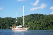
The waterway from Moore Haven to Fort Myers is wide and deep with little in the way of obstacles or challenges. One recent comment on this trip was whether or not we felt bored or lacked any excitement traveling along the many canals that interconnect the rivers, lakes and sounds that we have traveled to get to our final destination. My response is, absolutely not. Every canal and waterway has its own personality and each is to be enjoyed on its own merits. If I had one word to describe our transit of the
Okeechobee Waterway, it would be, spectacular.
 We left the Moore Haven City Dock
 at 9 AM. The entire day's run would be dictated by the 4 PM lock schedule at the
Franklin Lock. Due to the low water levels, Franklin is on a twice daily schedule, just as St. Lucie is at this time. There was no need for us to head out at the crack of dawn and then sit and wait when we arrived at the Franklin Lock too early. By 11:30 AM we had passed through the
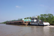
Ortona Lock, but that one, as with others, would open on demand. We would not motor through Ortona since this lock would drop us 7 feet. We were the only boat in the lock and, unlike St. Lucie, had no problem with turbulence since the gates were opened in front of us to let the water out and we did not have to deal with it rushing in. The whole process went very quickly, and before we knew it, the gates were opened and we were heading west once more toward our destination.
We passed through the Fort Denaud Swing Bring, and because of its 9 feet clearance, we had to wait a moment for an opening. At 2:50 PM, we were under the Alva Bridge which is high enough for our 21-foot air draft to get under without an opening. The waterway along this entire section is very beautiful and full of very large, and we can only assume expensive, homes with very green lawns, compliments of the irrigation systems pumped directly from the fresh water canals. The wildlife was also abundant and we saw many unusual sightings. Among the osprey, eagles, cows and horses, we also saw alligators, turtles and a camel. Yes, that is correct, I said a camel. You can imagine our surprise when we saw some horses grazing in a back yard and noted how strange one of them appeared to be. With a little closer examination, we discovered that this was not a strange horse, but rather a camel grazing side by side with them. At that point, we figured we had seen about everything on this trip. Most of the day was spent at a leisurely pace of about 5 miles per hour, enjoying the scenery and trying to time our arrival at the Franklin Lock.

We arrived at Franklin about 10 minutes to four. We had called the lock on the VHF Channel 13, about 3 miles out, to alert them that we were on our way and would be locking through west bound. As with all of the lock tenders, we received a very prompt and courteous reply and when we arrived, we waited only a few minutes to enter. Once again, we were the only boat in the lock, and this time, we again had to tie up to the wall. This lock would lower us another foot and a half and would be our final lock for the Okeechobee Waterway. The process was easy and painless and we hardly noticed the water leaving the lock except for the fact that we were getting lower on the wall. Shortly after we exited the lock, we were officially on the Caloosahatchee River and within striking distance of our destination. But we would not arrive at journeys end today, so a decision as to where to anchor for the night was needed.
 We looked at a couple of possibilities
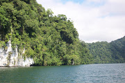
 on the charts and in our guide books, and it was after deciding to try one that we discovered another. After passing through the railroad bridge on Beautiful Island, yes that is the name, we turned at red marker "22" and took a channel with private markers that leads to some man-made canals. As we proceeded down the channel, we found plenty of depths in the 8- to 9-foot range. The turn into the canal looked very narrow and not very inviting. We noticed that there was a lonely red marker "12" well past the turn toward the canal and then nothing beyond that. We decided to continue on toward that marker and see how the depths held. We stayed in 8 to 9 feet and when we felt secure that we were not going to block any traffic, we dropped the anchor, GPS coordinates 26 41.415' N and 081 49.875' W, in 9 feet. We were, in fact, behind a small spoil island that was apparently a nesting ground for a large group of
Wood storks. These endangered white birds with black wing tips and gray or black heads made quite a bit of noise and were coming and going until the sun went down. Being gregarious and friendly, they also shared their island with a few pelicans and cormorants. It turned out to be a fabulous anchorage. We had a nice breeze coming down the Caloosahatchee that cooled us for the evening and the birds quieted down at sunset. We probably would not recommend this anchorage in heavier weather since it is pretty exposed.
We slept in again in the morning since we had a short run to Ft. Myers Beach, only a little over 26 miles away. The Caloosahatchee got wider as we headed west and finally we went under the bridge south of Ft. Myers and into San Carlos Bay. At this point, we were almost in the Gulf of Mexico and it had been years since we passed this way. San Carlos Bay was kind to us this morning and we made the turn toward the channel into
Ft. Myers Beach. Once inside the harbor, the entire area is an Idle Speed, No-Wake Zone. We called the marina where we would be staying and advised them of our location. At idle speed, it would take another 20 minutes or more to reach them. Just after noon, we were tied up at the
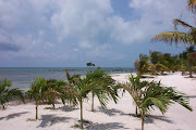
Snook Bight Yacht Club and Marina in Ft. Myers Beach. This would be our destination, for the next several weeks at least. Susan is excited because there is a Publix supermarket right next door and the beach access is just across the street.
A few facts and figures to ponder. We traveled 1,305 miles from Pasadena, MD to Ft. Myers Beach, FL and were underway a total of 19 days. We took two lay days to visit with friends and rest. We were weathered in at Reedville, VA for 5 days. Once we reached Norfolk, VA, we had no weather delays along our route. We burned a total of about 400 gallons of fuel, still have around 90 gallons in the tank and spent a total of $1,249.00 to fill the tanks. This gave us an average burn rate of about 2.25 gallons per hour. Our expenditures on dockage were pretty high on this trip, with a total of $564.00. Food costs were $445.00 for groceries and $246.00 for dining out. Repairs and maintenance costs were $137.00, laundry $22.00 (our friends helped keep this down), and $31.00 for miscellaneous items. Our total expenses for the trip, plus or minus a few dollars comes out to $2,694.00. The big question is, now what? We will have some work to do while we are here. And of course, the boat projects will begin again; they have just been temporarily on hold. The Ford Lehman did a magnificent job of getting us here without a single complaint, running a total of 180 hours. But we did find a couple of leaks along the way that need to be addressed so that they don't get worse. We will also try and have some fun and enjoy the Florida sunshine and warm weather. After all, that is why we are here! Stay tuned.

 We left the Moore Haven City Dock at 9 AM. The entire day's run would be dictated by the 4 PM lock schedule at the Franklin Lock. Due to the low water levels, Franklin is on a twice daily schedule, just as St. Lucie is at this time. There was no need for us to head out at the crack of dawn and then sit and wait when we arrived at the Franklin Lock too early. By 11:30 AM we had passed through the Ortona Lock, but that one, as with others, would open on demand. We would not motor through Ortona since this lock would drop us 7 feet. We were the only boat in the lock and, unlike St. Lucie, had no problem with turbulence since the gates were opened in front of us to let the water out and we did not have to deal with it rushing in. The whole process went very quickly, and before we knew it, the gates were opened and we were heading west once more toward our destination.

 We looked at a couple of possibilities on the charts and in our guide books, and it was after deciding to try one that we discovered another. After passing through the railroad bridge on Beautiful Island, yes that is the name, we turned at red marker "22" and took a channel with private markers that leads to some man-made canals. As we proceeded down the channel, we found plenty of depths in the 8- to 9-foot range. The turn into the canal looked very narrow and not very inviting. We noticed that there was a lonely red marker "12" well past the turn toward the canal and then nothing beyond that. We decided to continue on toward that marker and see how the depths held. We stayed in 8 to 9 feet and when we felt secure that we were not going to block any traffic, we dropped the anchor, GPS coordinates 26 41.415' N and 081 49.875' W, in 9 feet. We were, in fact, behind a small spoil island that was apparently a nesting ground for a large group of Wood storks. These endangered white birds with black wing tips and gray or black heads made quite a bit of noise and were coming and going until the sun went down. Being gregarious and friendly, they also shared their island with a few pelicans and cormorants. It turned out to be a fabulous anchorage. We had a nice breeze coming down the Caloosahatchee that cooled us for the evening and the birds quieted down at sunset. We probably would not recommend this anchorage in heavier weather since it is pretty exposed.


Being in Fort Myers you are not too far south of our waterfront home with an empty slip. Should you find your way up here (Treasure Island . . . just inside John's Pass Inlet from the Gulf to the ICW, about an hour and a half cruise south of Clearwater), plan to spend a couple nights at our slip. We cook a great meal, there's 30amp and filtered water at the dock, and plenty of services nearby we can get you to including a newly opened mega-West Marine store.
ReplyDeleteThank you for your kind offer and if we get up that way we will be sure and look you up. Drop us a line via this comment section with your contact information. We won't post it of course. Much appreciated and if you get down around Ft. Myers any time, be sure and stop by to say hi. Chuck and Susan
ReplyDeleteLove the blog. Wondered why you chose to go against the traffic, heading south into steamy Florida summer rather than north to cool New England weather?
ReplyDeleteJohn Schieffelin
Jamestown, RI
John, Good question and often ask. We have been based out of south Florida for over ten years so this is a choice of coming back south and not just deciding to head south. Work is the main reason we are here and the fact that we won't be doing any long term cruising until we have the boat finished. So we made the choice to come south and work on it and make some additional income instead of staying north. We really like living in south Florida. Besides, we have always gone the wrong way. Chuck and Susan
ReplyDeleteChuck & Susan,
ReplyDeleteGreat read about your trips. Getting ready to retire soon and have a question for Chuck. Would it be possible to handle your boat single handed? In other words this trip from MD to Ft Myers that you completed, could you have done it single handed?
Thanks and looking forward to reading more of your posts.
Walter
Walter, yes the trip could be done single handed. I did single hand for several years on a smaller sailboat and did the ICW. To do this, though the boat would need some extra consideration for a single hander, such as dock lines and fenders always ready to easily deploy, being sure there was help on the dock when coming into a marina, and careful planning for being two steps ahead. The biggest challenge would be the locks, but we know of other single handers that do this all the time. We considered that I might have to do part of the trip alone because of commitments Susan had, if we were delayed. It was not something I was overly concerned about. Single handing just means practice, practice, practice, with many different types of maneuvers. Good luck with the retirement. Chuck
ReplyDelete