At our appointed time, we left the docks and headed south into the state of Florida. It was really good to be back and the weather was improving, albeit still windy from the south. We had considered running outside from Fernandina to St. Augustine, but the winds had not lightened yet and the ride offshore would be uncomfortable. In addition, there are some shoaling problems at St. Augustine Inlet and two boats have been lost and one skipper killed. Not the conditions we wanted to subject
Beach House to. We knew there were a few problem spots with shoaling south of Fernandina, but it is not like we have not been dealing with this along the way. So off we went, straight into the wind and an adverse current, since the tides were running out at St. Mary's.
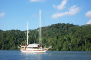
 On the South Amelia River
 between red markers "34" and "36," we found 7 feet of water in the channel. With the tide state at the time we transited, the depths would only be 4 1/2 feet at low tide. Enough draft for us to pass, but barely. Boats with deeper drafts would surely be grounded. A little farther along between green markers "39" and "41," our depths were 9 feet, making it 5 1/2 feet at low tide. There were several areas that would only be 6 to 7 feet at low tide in the same area. It had been several years since we transited this section of the waterway. With our former sailboat,
Sea Trek, we always transited between the St. Mary's River and St. Augustine on the outside, waiting for good weather if we had to. Another reason to not have to keep a schedule. Maybe it was time for us to do another inside run to get familiar with changes along this section of the waterway.
Nassau Sound was pretty much the same as every Sound we have transited so far. Wind against tide and very choppy conditions. By now we were getting so used to waves breaking over the bow that we hardly noticed. The weather was pleasant enough that we could finally spend the day in the flybridge instead of the inside steering station. By 10 AM, we were crossing the St. Johns River where it crosses the ICW. There are two major rivers that have to be crossed on the way south, The Savannah River and The St. Johns. The currents running up and down these rivers can surprise the unprepared helmsperson if they are not aware or not expecting it. The St. Johns is probably the strongest, and once it grabs the boat, will very quickly carry it up or down river depending on direction of the current. We virtually had to steer almost directly downriver to cross it, and we entered the ICW channel on the south side going sideways to head into the channel. This is always a sphincter tightener since there are several shoal areas and rock piles that are very near the channel. But all went well and we made it without incident. This is one of those "what if" spots for me. The what ifs start flowing and are hard for me to stop. What if the engine quits? What if the prop was fouled? What if something else broke? The ship channel is 50 feet deep or more and the current extremely strong. If something happened, trying to get an anchor down would be very difficult if not downright dangerous. The option is to get swept out to sea, not to mention the possibility of encountering a ship transiting the river at the same time. You really have to put this stuff out of your mind quickly and concentrate on getting the boat across the river.

We passed through St. Augustine with no more than a wave since this is another favorite stop that was not to be this time. Transiting the St. Augustine area requires that as you pass the Usina-Vilano Beach Bridge, you need to head to red marker "60" which makes it seem like you are heading out the inlet. This is very necessary since cutting this marker short will put the boat in some very shallow water. Both TowboatUS and SeaTow have done very well here and can usually be seen hanging around most of the day. Our goal was an anchorage just a few miles south behind flashing red "18" right off the waterway. When we arrived, the anchorage was full of boats that had been displaced by the installation of moorings by the city both north and south of the Bridge of Lions. We continued on to a couple of other spots that looked interesting on the chart. The first was a small channel at Butler Beach on the east side of the waterway. It is a recommended anchorage in a very popular anchorage book. As we entered, the channel the depths quickly went from 13 feet to 4 1/2 feet. We slammed on the brakes and backed out the way we came in. This certainly would not work. The next couple of possibilities were just wide spots in the waterway, but when we checked them out, we found no water. A sailboat going north turned into one of them and abruptly ran aground. Fortunately, he was not going very fast and easily backed off and continued north. It was now 3 PM and there were very few prospects for anchorages south of our position. We discussed anchoring in Matanzas Inlet, but the 15 knot winds could make anchoring in strong currents near an inlet uncomfortable. We decided to have a look as we passed by, but to find alternatives farther south. We still had 4 to 5 hours of daylight to get somewhere. So much for this being a short day for us.

Matanzas Inlet is another section of the waterway feared by mariners for as long as we have been doing this. It is very narrow, with swift currents and constantly shifting shoals. It had been dredged about a year ago, but many boaters were still reporting groundings and problems. So we approached the inlet with a great deal of caution. It really turned out to be a non-issue. Approaching the inlet, we found plenty of water in the channel. Where most boaters get into trouble is crossing the inlet and not believing the channel markers. The green markers here need to be kept on the port side of the boat if you are going south or the starboard side if going north. The channel makes it appear like the boat is going to run up on the beach so folks panic and turn on the other side of the greens. They promptly run aground and call SeaTow or TowboatUS. Another moneymaker for them. We stayed in the channel with one foot on the beach, and the shallowest depths we saw, and we were at low tide of course, was 8 1/2 feet at green marker "81D." Most of the depths, with the exception of a couple of 10 1/2 feet spots, were 17 to 18 feet. We also noted that anchoring in the inlet off the fort would be a nice stop for us at some other time in more settled conditions. We pushed on south, working on plan D or E or maybe even F.

It was obvious we had enough time to easily get to Palm Coast at about Statute Mile 803. We would not arrive until around 6 or 6:30 PM and we decided to stop at Palm Coast Marina. This trip was turning out to have more marina stops for us than ever before. We had stayed at Palm Coast before and liked it a lot. They are very cruiser friendly with several long time live-aboards and the marina managers are former cruisers. The marina has a very pleasant feel, is well-kept, has a great ship's store and lounge, clean restrooms and near enough to shopping that you can walk. But they close at 5:30 and we would arrive after 6. A phone call proved this to be no problem, as we were told to tie up at the open space on the face dock and we could settle up in the morning. We tied up at the dock at 6:15 PM, a couple of tired pups. Our short day turned into a pretty long one. Traveling on the ICW and trying to cover the distance we are, the crew needs to be very flexible. The marina had left us keys for the heads in the mailbox and a welcome sheet. We were again tied up in a marina, plugged in to power and looking for a good night's sleep so we could start all over the next day. And sleep well we did.

The trip from Palm Coast to Titusville went pretty much the same as every other day had gone. We were making great time and almost caught up with our original schedule after the five day delay in Virginia due to weather. If we made Titusville, we would be right where we planned to be when we shoved off from our marina in Maryland. Our plan for the evening was to anchor off the Titusville Municipal Marina for the night and then go in first thing in the morning and pick up a slip. We have a very good friend that lives here so we planned to spend Saturday with her. We arrived at about 4:30 PM and found a great spot to drop the hook. It grabbed the first time and we started to settle in for the evening. That's when we heard it. That unmistakable sound of a Florida thunderstorm. I looked over my shoulder and saw the dark clouds, heard the rumble and saw the lightning. It took us all of two minutes to get the anchor back up, get into the marina entrance channel and get them on the radio for a slip assignment. There was no problem and they had plenty of room. The dock attendant was waiting for us as we arrived and we backed into the slip to tie up. And that was when we realized what was happening. A cloud of black love bugs had encompassed the boat and the decks, sides and about everything else was covered with the little buggers. And wouldn't you know it, the zipper on the side door chose just that time to break. We were tied in the slip and crushing love bugs under our feet wherever we walked on the deck. Just another fun experience to add to the blog and the log book. A day of rest would be very welcome by now, but the love bugs would stay with us for as long as we were here.

 On the South Amelia River between red markers "34" and "36," we found 7 feet of water in the channel. With the tide state at the time we transited, the depths would only be 4 1/2 feet at low tide. Enough draft for us to pass, but barely. Boats with deeper drafts would surely be grounded. A little farther along between green markers "39" and "41," our depths were 9 feet, making it 5 1/2 feet at low tide. There were several areas that would only be 6 to 7 feet at low tide in the same area. It had been several years since we transited this section of the waterway. With our former sailboat, Sea Trek, we always transited between the St. Mary's River and St. Augustine on the outside, waiting for good weather if we had to. Another reason to not have to keep a schedule. Maybe it was time for us to do another inside run to get familiar with changes along this section of the waterway.


Hi Chuck and Susan,
ReplyDeleteOnce again, thanks for the details and the photos. At some future date we'd love to take our Sand Castle farther south and explore where you are. I am looking forward to any photos you might take crossing Lake Okeechobee. Your website is a fantastic resource and I appreciate all the maintenance photos and explanations. I am looking at getting the hose kit from American Diesel and changing the oil coolers and reaming the heat exchanger sometime this year. Always something to learn. If you ever compile/publish a book about your maintenance and adventures, give a holler.
Fair winds,
Ben & Debbie
on Sand Castle
Ben and Debbie, Thanks for the kind words and good luck with your projects. We plan to be at the St. Lucie lock tomorrow afternoon and we most certainly post info and pictures of our transit. That is if the locks will be open. The drought has really lowered the lake levels. We will report on our progress. Chuck and Susan
ReplyDelete