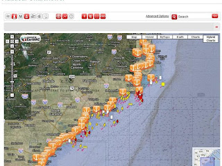
By Susan Landry
(Chartlets by Susan Landry, not to be used for navigation.)
Our cruising posts in the past have always included our favorite anchoring spots. As the snowbirds head south this fall, some for a repeat performance, some for the first time, they’ll be looking for secure anchorages for the night in the ICW. We try to average about 50 miles per day and what follows are our suggestions without marina stops.
Upon entering the Waterway in Hampton Roads, VA, one finds a drastic contrast to the wide open space of the Chesapeake. The first anchorage that you will encounter on your way south is near Fort Monroe at Old Point Comfort. Entering between the highway tunnel entrance to the west and the point to the east brings you into Mill Creek via Phoebus Channel. This is the first possible stop upon exiting the Bay. Need more protection? Tuck up into Hampton just a mile or so west and north.
For a relatively short jaunt the next day of only 25 miles, you can stop in Great Bridge, VA at SM 15 and tie up for free at the bulkhead to starboard just south of the lock, or at another dock to port just south of the bridge. There is no electricity, water or facilities here, but again, tie up is free. You can, however, leave your trash in the cans provided, and it is a very short walk to shopping and restaurants.
If you decided to press on from Great Bridge to a more quiet, remote anchorage, Blackwater Creek scores high marks with this crew. At SM 30, the anchorage is entered by staying close to the south shore at R “46” to avoid the shoal making out from the north tip. Then, stay center channel and go back as far as you wish to anchor in 7 to 8 feet.
 |
| Buck Island/North River |
As you head farther south, you may decide to bypass Coinjock as a stopping point and make your way down to either north or south of Buck Island (SM 57) to anchor for the night, or to continue down closer to where the North River meets the Albemarle and anchor at Broad Creek (SM 61). Pick your side of Buck Island depending on wind conditions. On the north side, you will likely have to contend with wakes until after dark. Broad Creek, while almost 2 miles off the Waterway, is going to have better protection, especially is your draft is shallow enough to go all the way inside the creek and not have to anchor outside, leaving you exposed to the northeast.
The next day south takes you across the unpredictable Albemarle Sound. We recommend doing this in settled weather as this shallow body of water can work up a nasty chop. You can pull off to the side of the channel in the lower portion of the Big Alligator River or enter the Little Alligator River north of the swing bridge near the Sound. We have pulled off near marker G “31” in the middle of nowhere just north of SM 100. We got far enough out of the channel that the wakes were not noticeable. This was in the area showing 10-foot depths on the chart about halfway to shore. We thought it was a strange anchorage, but we were joined by three other boats later in the evening. We have also continued on around the corner into the more sheltered section of the Lower Alligator River to Tuckahoe Point (SM 104). Following the deeper water on your chartplotter will bring you to a secure and sheltered anchorage for the night. We have also seen a number of boats in areas of deeper water around Bear and Deep Points.
You have a couple of choices the next day, the first of which is to go a mere 20 to 30 miles to the beautiful anchorage due north of G “23,” just as you exit the 26-mile long Alligator-Pungo Canal. To anchor, head back into the small cove noted on the chart and drop your hook in 9 feet of water. This wild, unspoiled area presented us with an unrivaled sunrise. It has also been used by numerous boats to hole up and wait for tropical storms to pass over, as it has plenty of swinging room.
If you are in the mood for a town instead of the marsh, continue on to Belhaven (Pantego Creek) at SM 135. You will enter from the channel, through the breakwater, then continue on to the area just left of the channel near G “9.” This anchorage is somewhat exposed to the southeast, but is a nice stop nonetheless. Be alert for a dolphin feeding frenzy at sunrise. It is possible to tie your dinghy to the ramp near the hospital or enter the little channel and dinghy back to the town basin to tie to the breakwall. If you need provisions, a grocery store is 1 to 2 miles west of the downtown area. Downtown you will find numerous restaurants, a great hardware store, the post office and a library. An alternate anchorage with better southerly protection is next door in Pungo Creek. This crew has sat out raging winds here and the anchor never budged.
The next day will take you to Oriental or Cedar Creek between SM 181 and 187. There are places to stop in between if you don’t feel like running the full 50 miles. Consider side creeks off Goose Creek as alternatives (Eastham or Campbell) or rivers and creeks off the Bay River (Bear, Long and Broad Creeks) just south of there if the Neuse River is acting up. If you make it to Oriental, you’ll have the choice to anchor in the harbor, to anchor beyond the bridges if you have a shoal-draft boat with under 45 feet of air-draft or to tie to the town dock. Not feeling like a being around a crowd? Continue on to Cedar Creek at SM 187.5. Draft permitting (5 feet or less), tuck up into Jonaquin Creek for excellent protection all around.
Many folks stop each year at Beaufort, NC to anchor in either Town or Taylor Creek, but Mile Hammock Bay is a little over 50 miles from the Cedar Creek area at SM 245 and that is why we generally press on to this location. It is a very popular stop along the way and depending upon the time of year you are traveling, you may be sharing this anchorage with many other boaters. Don’t be surprised to see gunboats and helicopters maneuvering around providing many photo ops. Should you be unable to get to Mile Hammock due to activity at the firing range, there is a decent anchorage just south of the fixed bridge in Swansboro across from the town docks. The current is swift so check your anchor set carefully. If you can make it to Mile Hammock, you will be rewarded with a great anchorage with protection from all directions.
Our next stop at the 50 mile mark is Carolina Beach at SM 295. Again, we have those fall-back positions just in case. Those are Topsail Beach at Mile 263 and Wrightsville Beach at SM 283. Topsail is much easier to enter and deeper than charted. It is a pleasant alternative, especially if you make good time and want to keep going past Mile Hammock. Wrightsville is another spot where everyone stops, however Motts Channel is perpetually shoaling and we have a dislike of running aground. In Carolina Beach, you will find it deep in the areas adjacent to the three small islands. Our favorite spot is in the area just north the first island. The charted 33-foot spot does not exist, at least we haven't found it. Depths are more like 9-10 feet and drop to 6-7 as you approach the eastern side. Carolina Beach is the best spot to wait for favorable tides in the Cape Fear River. Running with wind and tide opposed there is just not fun.
 |
| Southport |
Once south of Carolina Beach, with the exception of some marginal anchorages around Southport and Little River Inlet, you really won’t have any truly great anchorages again until the Waccamaw River. In Southport (SM 309), your choices are anchoring in the small town basin or a free tie to the end of the town dock. You may also find some “dock and dine” alternatives at restaurants where they will let you spend the night as long as you have a meal. Know that the docks are subject to ICW wakes at these restaurants, making it a bit uncomfortable. A little farther down the way at SM 310, you may find a spot in Dutchman’s Creek (quite shallow) or in the canal known as Pipeline Canal at SM 311. Many boats are on permanent moorings up in the basin at SM 311, but you may be able to find a spot along the edge in the deeper water. Make sure your anchor is set well as the holding is iffy.
 |
| Calabash Creek |
In the Little River Inlet area, your choices are in Calabash Creek, if you can find adequate depth, and in the inlet itself in the wide area to the side of the channel, or just behind the island at the mouth of the inlet where it meets the ocean. None of these are great anchorages, but will do in a pinch if you can not make it the entire distance from here to the Waccamaw River, another 30-plus miles.
The Waccamaw is definitely one of our favorite cruising grounds and places to anchor. This is truly a beautiful place and one could get lost in the numerous creeks and adjoining rivers. The first spot to anchor is across from G “27” in Enterprise Creek at about SM 375. Our personal favorite is down less than a mile or so across from G “29” in the oxbow. We generally anchor on the southern side in toward the island to find a spot shallow enough in which to anchor so we don’t have to pay out too much rode. South of here and on to Georgetown are so many places to anchor, it’s hard to name them all: Price, Bull, Cow House, Thoroughfare and Jericho Creeks are the main ones. And don’t forget the lee of Butler Island.
South Carolina contains three of our favorite stops and Georgetown is one of them. Just north of SM 405, after you leave the Waccamaw River, Georgetown is a quaint place with friendly people and beautiful, historic homes. The anchorage, 7 to 8 feet in mud, is located all along the boardwalk lined waterfront, if you can find a spot among the numerous permanently moored local boats. The ride to the dinghy dock is so short that you won’t need your outboard; just row. Numerous restaurants and shops line the waterfront and there is also a convenient ATM directly across the street. You can’t miss the wonderful murals painted on the sides of buildings, depicting the old sailing days. We generally plan at least two days here.(Note that a devastating fire just occurred here on 9/25/13 destroying many waterfront businesses, but the town is still open for business and is a great place to stop.)
Getting to Charleston in one day from Georgetown may be a challenge for underpowered vessels. The good news is there are options. You can make it a short day from Georgetown and stop at Minim Creek (SM 415) or the South Santee River (SM 420), both of which we have used and give our stamp of approval. Here, you begin to enter the low-lying marsh and leave the forest surrounding the Waccamaw behind. Or, continue on farther south to near McClellanville and try Five Fathom, Awendaw or Graham creeks between SM 430 and 440. The choices don’t end there. Continuing on, you have Whiteside, Dewees, Seven Reaches and Inlet creeks between SM 451 and 461. Beyond that, you are committed to crossing Charleston Harbor. Check your chart for depths and protection as many of the above anchorages are sheltered only by marsh grasses and no trees, and some may not have the depths required for your draft.
Charleston, at SM 470, provides a number of different anchoring opportunities and is another favorite stop. We have anchored just next to the Coast Guard station as well as across from the city marina outside of the mooring field. Vessels that can clear the 56-foot bridge can anchor to port beyond the first bridge across the Ashley River. No matter where you choose to anchor, you will have to contend with a swift current. You can dock your dinghy at the city marina. The trolley system is an inexpensive and fun way to get to the grocery store, The Battery, the Straw Market or the wonderful museums in Charleston. It leaves regularly from the front of the city marina.
 |
| Wappoo Creek |
The Charleston to Beaufort run is possible to do in one day for slower craft, provided you catch the currents right and get an early start. Just beyond the restricted Wappoo Creek Bridge, you will find a secure and very attractive anchor in the oxbow near G “9.” Dinghy dockage can be had at the boat ramp or restaurant by the bridge. Many choose this spot in order to get ahead of the morning bridge restrictions and have a bridge-free run to Beaufort.
 |
| Stono River |
In case you don’t feel like pushing on, the area between Charleston and Beaufort offers a number of options to break the trip up into two pleasant runs instead of the 65-mile run straight through. A short distance beyond Elliot Cut in the Stono River, you will find a decent anchorage downriver to the south. Anchor on the west side of the river near the range markers. Church Creek at SM 488 is another of our favorites to break up this trip.
 |
| Toogoodoo Creek |
Once near the Dawho River at SM 497, an area prone to constant shoaling, you may need to stop for the day to await a favorable tide. Consider Toogoodoo, Tom Point or Steamboat creeks, all located within a few miles of each other, as comfortable, protected anchorages. Once through the Dawho and out into the South Edisto, you can turn north to anchor upstream. The Ashepoo River also provides a couple of decent spots around SM 511, including Mosquito Creek.
 |
| Bass Creek |
Once you enter the Coosaw River, you are nearing the home stretch to Beaufort, but in the event you want to stop, more options await you. At SM 521, the Bull River makes north and finds its way into Wimbee Creek. At SM 521.5, Parrot Creek heads south out of the Coosaw and meets up with the Morgan River. In the middle, enter Bass Creek to anchor in the first bend. Or continue to the Morgan River and head off to starboard to find a number of protected creeks locals use as hurricane holes, including Lucy Point Creek.
The ICW leaves the Coosaw River and enters Brickyard Creek. Shoal-draft vessels may be able to drop the hook in the oxbow marked by G “217.” Local knowledge has it that entry is best made from the south end. A better and more protected anchorage is in Factory Creek, just north of the Ladies Island Bridge. Although depths near G “1” at the entrance to the creek are close to just 6 feet at low water, depths are plentiful beyond there. Anchor close to the boat ramp for shore access, or check with the marina up the creek to tie there. Anchoring beyond the marina may give you a bit more swinging room. Provisioning, restaurants and hardware are within a close walk.
Beaufort, at SM 535, has always been a favorite of ours. We have never passed Beaufort by on our dozens of trips north or south. Many folks choose to anchor outside of the moorings near the town marina, and there is a dinghy/day dock provided there for boats anchored out. You can find almost anything you need in Beaufort, plus the waterfront has a number of excellent restaurants, shops and a manicured waterfront park, home to numerous festivals.
 |
| Bull Creek |
An alternative for a shorter day's run would be a mere 25-mile run to Hilton Head. One can anchor at the head of Broad Creek east of SM 560 past the last marina entrance, beyond the bend in the channel near G “19.” By staying in the middle of the creek, you are safely in 10 feet of water at low tide. The holding there is excellent and is a good place to sit out a gale. If you don’t need to tuck quite that far up into a creek, just past SM 565 is Bull Creek. A quick turn off the ICW and a trip of less than a mile brings you to a secure, roomy anchorage.
 |
| Herb River |
If you are running 50 mile days, the Herb River would probably be your next stop after Beaufort at SM 585. This will be your first stop in Georgia if you don’t run up the river to the city of Savannah itself. Anchor anywhere depths permit. Alternatives a short distance off are up the Vernon River near the town of Montgomery past SM 595 or Delegal Creek near SM 600.
Kilkenny Creek, at SM 615, is a favorite stop of ours. We used to just go in a ½ mile or so and drop the hook. In recent years, we have taken to going all the way past the marina to anchor in a wide area of the creek around a bend. This is another good spot to sit out nasty weather from the west as the treeline provides good protection. Georgia provides endless possibilities for anchoring. Before you even get to Kilkenny, you have Redbird, Cane Patch, Buckhead, an unnamed creek just north of G “105” and Big Tom Creek. Just after crossing St. Catherines Sound at SM 620, Walburg Creek runs along behind St. Catherines Island, providing yet another opportunity for a remote anchorage. At SM 630 is the Wahoo River, another convenient and easy to reach stop.
 |
| New Teakettle Creek |
New Teakettle Creek, just past SM 645, is roughly 50 miles from the Herb River. If you are pushing along, this will likely be one of your choices for the evening’s rest. Continuing on through Doboy Sound just prior to reaching the Mud River are the North, Darien and South rivers, between SM 650 and 655, any of which are viable stops for the night. We have chosen to use the South River on runs north or south. One of these anchorages may be necessary if you are waiting for high tide to pass through the Little Mud River. It is one of the most shallow areas in the AICW. At about SM 665 are the Frederica River and Wally’s Leg. These two anchorages are also popular. We have stopped at Wally’s Leg many times. Troup and Jove Creeks at SM 670 are other choices.
 |
| Lanier Island |
As you continue south on your way to Florida, stop at St. Simons/Lanier Island at SM 675. As you leave the AICW, round the shoal marked by G “1,” continue heading north leaving G “3” and “5” to port and you will enter an adequate overnight anchorage with 11 feet over sand/mud. Just north of here is a sizeable marina. This anchorage is untenable in strong south-southeasterly winds as it is just north of the wide open St. Simons Sound.
As you head south through St. Simons Sound in the morning, be aware of the many shrimp boats who will share the water with you. They sometimes follow an erratic course. Although Georgia does not encompass a long stretch of the AICW, it has many pleasant anchorages. You can easily make Florida in one day from St. Simons, but you may want to slow down and enjoy some of the most pleasant anchorages you will find just about anywhere, because once you reach Florida, they are not nearly as plentiful.
Once you pass behind Jekyll Island and through the Sound, you will come to Cumberland Island, a truly beautiful and unspoiled place. Anchorages on the north end of the island include the Brickhill River and Floyd Creek just past SM 695. This area is your 50-mile-run stop zone. At SM 710 is the most popular anchorage behind Cumberland Island. Flashing 4s “E” marks the southern tip of the shoal on Drum Pt. Island that separates and protects the anchorage from the AICW. Most boats proceed north to anchor in the 9- to 15-foot areas. Dinghy ashore and bring your camera. Only accessible by ferry, you will find wild horses and long stretches of beach with great shelling and few people.
 |
| St. Mary's River |
A final side trip before reaching Florida is up the St. Mary’s River to the little town of St. Mary’s, GA. It is only a few miles upriver to this pretty little town with cute shops and good restaurants. A number of boats have made it a Thanksgiving haven for boaters who aren’t flying out to be with family. It’s a good place to stop and relax with over 700 miles logged since Norfolk. Once south of here, you are finally in Florida.
If you found this post helpful or informative, don't forget to add a comment and let us know. We always appreciate hearing from our readers.


Good info! I bookmarked this blog for our trip south from Isle of Hope. Thanks!
ReplyDeleteWe're happy you found it helpful. These are the anchorages we have used over the years and we anchored in all but Calabash Creek with our 6 foot draft sailboat. So depending on your draft, you should have no problem. Have a great trip and stay safe. Chuck and Susan
ReplyDelete