The next morning started overcast but quite warm. A 50% chance of rain meant we also had a 50% chance it wouldn't rain. Yeah, right. Our anchorage for the night was not yet decided, but a few options were available. The plan was to transit about 50 miles of the river before we stopped and 50 miles is not a long day for us. That's probably why we got a later start than usual;
Beach House didn't get off the dock until almost 9 a.m. One of our neighbors from the night before, a sailboat, had already gotten underway, but we knew we would catch up later. The owner was singlehanding and also heading for Demopolis to leave his boat. Later in the day we would get quite an education in anchoring on a wide and deep river system.

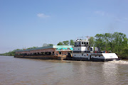
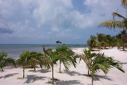
Information on anchorages along the river is scarce, and the river itself presents some interesting challenges. Not since cruising the Pacific coast have I experienced the difficulty in finding an anchoring spot where the water is shallow enough to not need all of the anchor rode for scope. That wouldn't be an issue except that using a lot of scope would allow the boat to swing out far into the river and this could be a serious problem at night when the sometimes 200-foot tows came cruising down the river. We didn't want to be swinging out in their way. One option we considered was tucking in behind one of the several marked shoals in some of the river bends. The shoals are marked with buoys and too shallow for the tugs to maneuver. As they rounded the turns they would safely pass any boats anchored. We sounded a couple and they looked like good possibilities, but the need to press on kept the boat moving. One reported anchorage was near mile marker 65, the Nanafalia Bridge. The bridge abutments the tows had to negotiate kept them center channel, somewhat protected the anchoring spot.

As we approached the bridge, it was pretty obvious that this was just a wide spot and not as protected as we had hoped. But since it was just an overnight stop, we decided to give it a try. What a surprise to find water depths of 25 to 30 feet right up to the river banks. I suppose we could have simply pulled along the banks and tied to a tree, but the decision was made to push on and see what else we could find. Several miles farther on there were a few options to explore. One was a wide indentation that we attempted to back into without success, the depths went from 25 to 4 feet at the river's edge. Another option near a launch ramp proved to have a rocky bottom and the anchor just skipped along the rock. Our third attempt was at a small creek called Tuckabum. A previous pass showed a shallow enough space just outside the creek, or we could have attempted to drop an anchor in the river and backed into the very narrow creek. There was no way to tell if the bottom contained stumps or obstructions if we attempted to back in. Plus, the overhead trees would block our satellite TV dish, so we opted to anchor just outside of the entrance. One other consideration was that a small fishing boat had gone in earlier and if we had backed in, the creek was so narrow that the fishing boat would not be able to get back out past us.
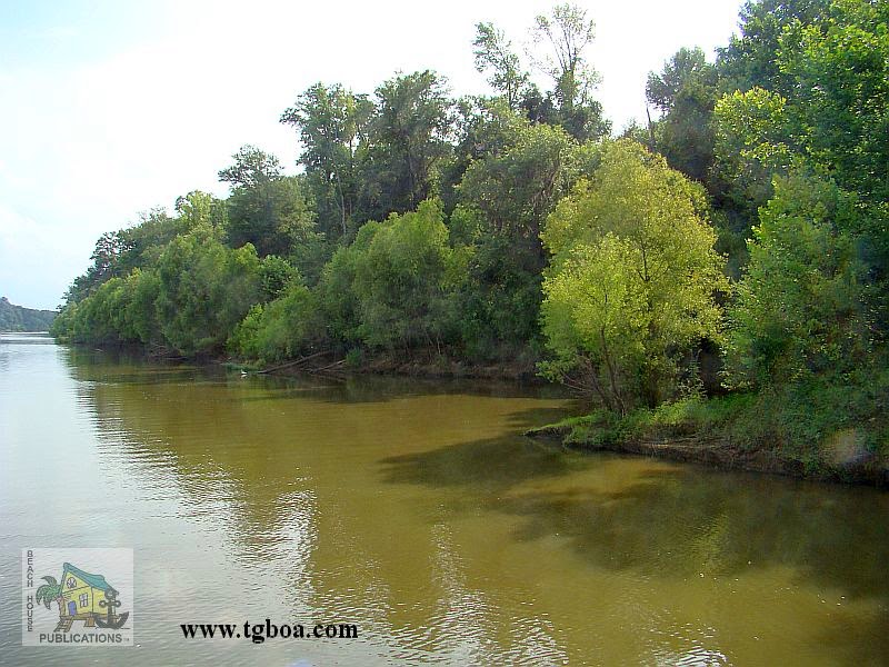
Feeling our way in, we found a spot with 14 feet of water almost right along the banks. There was still the issue of swinging out into the river during the night. To hold us in place, we dropped our primary anchor and backed down until we had more than twice the scope we would need. At that point, we dropped our secondary anchor and pulled forward on our primary with the engine in neutral until the boat was positioned between the two. Care had to be taken since we couldn't use the engine for fear of fouling the second anchor in our prop. The boat was pulled forward by hand and the aft anchor given a tug to try and set it. The aft anchor rode was then pulled up along the side of the boat until it could be secured to the stern cleat. This gave the boat bow and stern anchors rather than swinging on both rodes as is done in a Bahamian Moor. Now things were secure enough to stay put along the banks and well out of the river. One odd occurrence was being swarmed by attack moths as we set the anchors. Then, no sooner had things settled down when an afternoon storm rolled through.

As the rains approached, the wind began to build. First 10 knots, then 20, then 25. Of course it came from directly down the river rather than from either side where there was plenty of protection from the high treeline. The second anchor was a concern since we were not able to set it in our normal fashion. Add to that we had never had
Beach House lay on a stern anchor before. In a short time, we felt secure that the second anchor was holding and as quickly as the storm came up, it passed. Just shortly after dark, two large tows passed on the river, both using large searchlights to light up the river ahead of them.
Beach House was tucked securely out of the way and the rest of the night was very quiet and peaceful. We felt very secure in our anchorage choice. In the morning, we noticed that the current had increased considerably overnight and it was going to be a much slower trip upriver. We also saw lots of debris in the water with everything from plastic buckets to large trees. The day would be spent dodging a lot of this debris.
I'm not sure why we had gotten in this habit of sleeping in and getting a later start. Usually while cruising, the anchor is up and
Beach House is underway as soon as there is enough light to see. This river cruising seemed to make us a little lazier. Perhaps that's where the term "up a lazy river" comes from. It was nearly 9 a.m. before both anchors were secure on deck and our journey continued. The final destination for this leg of our cruise was only about another 50 miles up the river. It would require transiting one more lock and we hoped this time it wouldn't be in the pouring rain. Our neighbor on the sailboat from
Bobby's Fish Camp had passed us while we were still anchored, and then we passed him a few hours later. In hindsight, we probably should have just matched his speed and stayed with him for the rest of the day.
By 3:30 in the afternoon, we were approaching the Demopolis Lock and Dam. A southbound, or downbound as they say on the river, large tow had asked us to stand by on the bend just before the lock, and wait until he passed. We obliged and once he passed us,
Beach House headed for the lock. We aren't sure whether it was from our conversation with the tow or from our AIS broadcasting our location, but well before we arrived, the Lockmaster called us on the VHF by name and told us he was expecting our arrival. We were instructed to tie on either side of the lock and he advised us as to which of the floating bollards would give us the best ride up in the lock. We chose to tie starboard side to and slowly entered the lock. As we approached, it was obvious why the current was strong on this leg.Water was tumbling over the dam so much that the mist from the falls was visible from quite a distance.
Beach House was soon in the lock and secured to one of the floating bollards. Then the Lockmaster called us on the VHF to announce we would have a wait.

The sailboat we had passed some time back had called the Lock to say he was about 20 minutes behind us and the Lockmaster decided to wait for him rather than do two lock-throughs. It made sense, but would delay us another 1/2 hour before the locking process could begin. During our wait, Steve, the Lockmaster, called us on the radio and assured us he had contacted the marina in Demopolis and they were not only expecting us, but someone would be waiting there until we arrived, however long that took. We spent the next 20 minutes chatting about the Demopolis area, the best restaurants in which to eat and what to do in the area. It was fun and entertaining and made the wait time very pleasant. Once the sailboat arrived and was secure, the locking process began, raising us up some 40 feet to the next river level. We were lucky enough to have no rain for the day, even though it did threaten a few time.We made a short video of our transit of the Lock and hope you enjoy it.

It was almost 5 p.m. by the time
Beach House exited the lock and started the short run to Demopolis Yacht Basin and the Kingfisher Bay Marina. We arrived 30 minutes later, and while there was no one at the docks to help us tie up, a marina staff member was on the VHF with us to give instructions on how to get into the marina where our slip would be for the night. We would move the next day to a more permanent slip. The marina is in a completely enclosed, deep basin with nearly new floating docks. There is the choice of covered or open slips. The marina has a haul-out yard, swimming pool, clubhouse with heads, showers and laundry, and a golf cart and courtesy car for transient boaters to use. This will be our location for the next few months while we finalize our 4th anchorage guide,
The Great Book Of Anchorages, The Gulf Coast. It will be good to just rest for a while and not have to be constantly on the move. We love cruising, but at times we also need to just sit still. Even if we're working while sitting.


We use to always anchor bow and stern in the channel islands off California. The best way is to get both rodes on deck and tie the two bitter ends together. Coil the line so the stern anchor can be set first. Drop the stern anchor first and ease up to the spot you want to drop the bow anchor. Now you just pull back towards the stern anchor. The beauty of this method is that you can have greater scope on both anchors using the same amount of line. This is probably not a concern in 15 feet of water.. The other advantage is not having to back down to the correct spot for the stern anchor.
ReplyDeleteThanks Charles. That's indeed another way to anchor bow and stern.I have a lot of fond memories in the Channel Islands. Chuck
Delete