
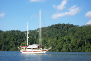
No matter how many times we go to the
Bahamas, we cannot wait to return. Its pristine beauty never ceases
to amaze us. Like many cruisers, we have our favorite routes and
favorite islands. Also like many cruisers, our favorite way to truly
sample the flavors of the Bahamas is finding those perfect spots to
anchor. Anchoring in the Bahamas offers some unique challenges that
aren’t often encountered cruising inland coastal waters. Bottom
conditions can range from excellent in sand to very difficult in
scoured-out rocky channels. Some of the most problematic bottom
conditions will be heavy grass and thin layers of sand over a rock
base. Heavy grass tends to foul the anchor, and thin sand over rock
doesn’t give the anchor a chance to dig in. We have found generally
good holding in most of the anchorages we have visited on our trips
that have covered from the Abacos, to the out islands, to the extreme
southern islands. We have also encountered some of the more
problematic conditions firsthand. Anchoring close to a cut or a break
in a Cay can result in a very rolly anchorage.

This route takes you over
to the Bahamas via Bimini, then a visit in the Berry Islands, then
over to and down the Exuma chain. Clearing in at Bimini, you can
anchor at a couple of spots. The most preferred is off the docks of
the Big Game Club in Alice Town. The marina offers dinghy access to
town. The second is at the northern end of the harbor near the new
resort and casino in North Bimini. With any anchorage in the Bahamas,
check to be sure the anchor is well set and be aware of the strong
currents in Bimini Harbor. The next night, due to the distance across
the Banks, you will likely anchor on the middle of the banks well the
rhumb line to avoid nighttime traffic. If you pick that good weather
window, you should have benign conditions for anchoring in the middle
of nowhere. The water depths are uniformly 8-12 feet so anchoring
there is not a problem. Show a very bright anchor light! Upon
departing the Bimini area, you will either have to head north to
North Rock or south to North Cat Cay to cross onto the Great Bahama
Bank. For deeper-draft vessels, you will have better depths on the
northerly route across.

After clearing in at
Bimini, one can head north to North Rock, then head almost due east
to Great Harbour in the northern end of the Berry Islands. Leaving at
daybreak and heading across the banks will put you close enough to
the Berry Islands to anchor and finish the trip in the morning for
slower vessels or a long day to anchor at dusk for trawlers. This
gives you an opportunity to begin your Bahamas trip in The Berry
Islands and cruise through the many delightful anchorages. The
anchorage at Bullocks Harbor gives easy access to the settlement and
the town dock for landing the dinghy. Beware of the thick grass on
the bottom and look for a sandy patch to drop the anchor. Inside
Hawksnest on the east side of Great Harbor Cay is a spectacular
anchorage with miles of white sandy beaches. Soldier Cay, Hoffman’s
Cay, White and Fowl Cay offer days or even weeks of solitude and
exploration. Cruisers can easily spend a month or more just exploring
the many anchorages throughout the Berry Islands.
Nassau on New Providence
is usually the next port of call. Anchoring in the harbor can be
difficult. Nassau Harbour’s bottom is like trying to anchor on a
parking lot. It is hard with little to grab a hold of except
hurricane chains. The current has scoured it clean. There are a
couple of sandy patches with fair holding just west of the bridge to
Paradise Island or off the eastern channel near Nassau Harbour Club.
Currents are strong and boat wakes are a problem. If you don’t need
provisions or have already cleared in, we recommend anchoring at Rose
Island, northeast of New Providence. It’s far away from everything
but a good place to stage to head south into the Exumas.
Your next destination
will be the Exumas. Starting at Allen’s Cay at approximately 24.45’
N and running south to Georgetown at about 23.30’ N. Anchorages are
plentiful and each should be considered based on the how much wind
protection you need and from what direction. The trip from Nassau or
Rose Island to Allen’s is about 28 NM and takes you across the
“dreaded” Yellow Banks to the Exuma chain of islands. The banks
are not as formidable as some cruising guides would suggest. Ensure
you transit the area with the sun high overhead and have someone in
the bow or flybridge or as high up the mast as needed for a good view
of your path ahead. The coral heads are easily negotiated.

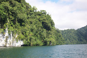
As you travel south in the Exumas, your
daily runs will be short so you don’t miss any of the wonderful
anchorages in the 100 or so miles to George Town. Some of the
highlights are Allen’s Cay, with its greedy iguanas, Norman’s Cay
with its western beach and cozy inner anchorages, Warderick Wells,
possibly the most beautiful place on the planet, and Staniel Cay with
its friendly townspeople, the Thunderball Grotto of James Bond fame,
swimming pigs and plentiful anchorages in and around the town and
outlying cays. Farther to the south is the settlement of Black Point,
another friendly outpost, and Farmer’s Cay with its yacht club
festivities. Between there and George Town are any number of remote
locales to drop the hook. Deep-draft boats will likely exit at
Galliot Cut to make for George Town (a trip of about 34 NM), while
shoal-draft vessels can travel along the inside to Ray Cay, Square
Rock or Glass Cay Cuts before heading out into Exuma Sound for George
Town at Conch Cay Cut (a trip of about 13-15 NMs).
Many boats just make for
George Town and plant themselves there for the duration. Once you get
there, it’s easy to see why. There are activities every day on the
beaches on Stocking Island, places to provision ashore and friends to
catch up with. George Town does present a number of anchoring
options. Anchor off Stocking Island in the various locations–Church
Bay, Volleyball (Hole 1) or Sand Dollar (Duck Bay) Beaches–or raise
the anchor and head across to anchor just off the town in Kidd Cove
for that provisioning or laundry that needs to be done. Or, follow
the path into Red Shanks behind Crab Cay on the south side of the
harbor.
When you are ready to
depart George Town, before you grow to the bottom, you have a number
of options. If you have a little extra time, head back north in the
Exuma chain until back to Warderick Wells again. It is so wonderful;
it deserves two stops on anyway. From Warderick Wells, exit Warderick
Cut and make the 30 NM run northeast to Powell Point on Eleuthera.
Heading around and into Rock Sound, one finds yet another friendly
Bahamian Settlement with an anchorage just off town. Pick your spot
in the sound based on the forecast wind direction.

From Rock Sound on the
west side of Eleuthera, there are any number of great anchorage
stops, including Ten Bay and South Palmetto Point, Governors Harbour,
Hatchet Bay (360 protection), Rainbow Bay, Current Cut Settlement and
Spanish Wells. None of the anchorages are more than 20 or 30 miles
apart, making for easy daily runs. The area around Spanish Wells is
deserving of a few days at least of exploration due to its
interesting past. Take the ferry to Harbour Island to explore Dunmore
Town.

From Spanish Wells or Royal Island,
you’ll then make your way north to the Abacos to wrap up your
winter excursion through the Bahamas. The crossing to Little Harbor
from either Spanish Wells or Egg Island ranges from 45 to 50 NM. This
may be one of the longest crossings you’ll have to make during your
stay in the Bahamas. Make sure you have a very good weather window
for this crossing. After crossing, enter through the reef between
Little Harbour and Lynyard Cay and head north for the anchorage
behind Lynyard, or west and south to the wonderful little harbor at,
you guessed it, Little Harbour if your draft will allow. The harbor
will be for shoal-draft vessels only and will be your key to rich
Abaco history and the history of the Johnston family who settled this
area. The Lynyard Cay anchorage is close enough to anchor and dinghy
to Little Harbour and provides good holding and protection from
prevailing easterlies.

From here, many more
anchoring opportunities present themselves as you work your way
north. Tilloo and Elbow Cays offer anchorages on their west sides,
only 10-15 NMs away. On the north end of Elbow Cay is Hope Town, a
must see. You will need to anchor outside of the harbor and dinghy in
due to the mooring field and docks inside–anchoring inside is now
prohibited. The hub of the Abacos, Marsh Harbour is only about 10 NMs
to the west and Man O War less than that to the north. You could
spend weeks in this area bouncing back and forth between these
wonderful places. Moving onward into the Sea of Abaco, some of our
picks for anchorages are Treasure and Great Guana Cays, then through
Whale Cay Pass to Green Turtle Cay. There are moorings in both basins
on Green Turtle, so you may want to anchor outside near Joyless Point
or off the New Plymouth Settlement, but you will be able to find room
inside as well; just watch the holding. We also love the anchorage at
Manjack and Crab Cays, about 5 NMs to the north of there. Powell Cay
is a short hop north of Manjack with Spanish Cay just beyond.
Once you reach Crab Cay,
you will need to decide if you will head northwest and visit some of
the other favored spots in the Abacos, such as Allans-Pensacola and
Grand Cays, or head west toward Hawksbill Cays and Fox Town. Your
exit from the Bahamas on the lower route will take you past Great
Sale Cay. Most folks anchor in the cove on the west side which offers
protection from the northwest through southeast. The east side of
Great Sale is also great for those occasional westerlies. Then, head
past Mangrove Cay and to anchor near West End. The next morning,
cross to Lake Worth Inlet, a distance of about 56 NMs, or to St.
Lucie Inlet, at about 67 NMs.
Anchoring Side Notes
Anchor
During our last journey
through the Bahamas the “Next Generation” anchor has proved
itself to be the best all around anchor we have used. Our choice is
the Manson Supreme, but there are others with very similar designs
and characteristics that will do as well. The prudent skipper will
carry a second anchor for those severe weather conditions and the few
times a second anchor is needed to deploy a Bahamian
Moor. The Bahamian Moor is two anchors set
off the bow at a 180° angle from each other, used to keep the boat’s
swinging circle limited to a small area. It’s good for strong
reversing currents, like those found in cuts, or where there is
limited space.
Finding the Right Spot
Anchoring in the Bahamas
offers some unique challenges. Often heavy grass will blanket large
sections of some of the better anchorages, which prevents the anchor
from setting properly. Look for sandy patches, seen as white patches
within the grass. Pull forward to the edge of the sandy patch, drop
the anchor and back down slowly until the anchor has set about in the
center of the patch. Once the anchor rode is stretched out, back down
slowly until you are comfortable the anchor has set. It’s a wise
idea to snorkel over the anchor to be sure it is indeed set.
Beware of what might look
like a sandy bottom but is actually a thin layer of sand over rock or
coral. If the anchor appears to be set, it may only be in a narrow
crevice and will release as soon as the boat shifts on the rode. Many
times the anchor will simply skip across the bottom. In this
situation, it’s often best to try and relocate to another spot.
In many of our anchorages,
good holding in deep sand is the norm. Even in a sandy bottom, small
patches of rock and coral are often present. Boats going to the
Bahamas should have sufficient amount of the correct size chain as a
primary part of the anchor rode. Most anchoring will be done in 10
feet or less, so a minimum of 100 feet is recommended. The more, the
better. Nylon anchor rode can and will chafe through very quickly
rubbing back and forth on a piece of rock or coral. Weather
conditions and wind strength and direction will play a very important
role in where to safely anchor. Make monitoring the weather and
knowing what conditions to expect part of your regular anchoring
routine. Most of all, enjoy, be safe and have fun.
BIO
Chuck Baier and Susan
Landry have been cruising together as a couple for almost 25 years,
first on their Mariner 40 Ketch, Sea Trek,
and currently on their Marine Trader trawler Beach
House. Chuck and Susan were owners of Beach
House Publications, publishers of The Great
Book Of Anchorages series of anchorageguides. The Guides cover the Chesapeake Bay, Atlantic ICW from
Hampton Roads/Norfolk to Key West and include the St. Johns River,
the Bahamas – The Route Most Traveled and the Gulf Coast from Cape
Sable to Mobile, including the Okeechobee Waterway. Chuck and Susan
have been freelance writers for over 15 years and have written for
almost every major boating publication and many online boating sites.
The duo have cruised the Atlantic and Gulf coast of the U.S., the
Bahamas, Turks and Caicos, and the northern and western Caribbean.
Chuck is former GM and Susan is former Editor of Waterway Guide.


Thanks for this valuable information, it is a great post. I would definately recommend TGBOA in addition to this. Hope you guys are well. Take care.
ReplyDeleteThanks for the kind words Will. We are doing great. Hope all is well with you.
Delete